Have you ever wondered how archeologists find buried ruins without digging up an entire field? Or how engineers know exactly where to build a skyscraper’s foundation without risking a sinkhole?
They aren’t using magic; they’re using Electrical Resistivity Surveys.
Think of it as an ultrasound for the Earth. By sending electrical currents into the ground, geophysicists can map out what’s happening beneath our feet in stunning detail. Let’s break down how this fascinating technology works, why it’s a game-changer, and where it’s used.
What Exactly is a Resistivity Survey?
At its core, an electrical resistivity survey measures how strongly the ground opposes the flow of an electric current.
Different materials have different levels of resistivity (measured in Ohm-meters, or $\Omega\cdot\text{m}$). For example:
- Low Resistivity: Water-logged clay, metallic ores, or contaminated groundwater conduct electricity easily.
- High Resistivity: Solid granite, dry sand, or hollow caves fight against the current.
By mapping these variations, scientists can create a 2D or 3D cross-section of the subsurface without moving a single shovelful of dirt.
How Does It Work? (The Science Made Simple)
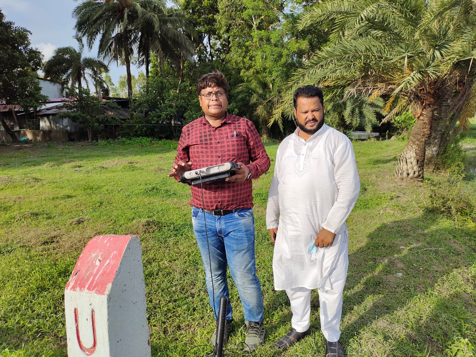
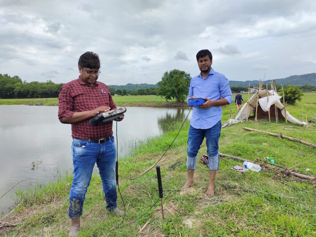
The setup for a typical survey looks like a high-tech game of lawn darts. Here is the standard process:
- Planting the Electrodes: A series of metal stakes (electrodes) are driven into the ground in a straight line.
- Injecting the Current: Two of these electrodes (the “current” electrodes) send a controlled electrical current into the earth.
- Measuring the Voltage: The other two electrodes (the “potential” electrodes) measure the voltage drop as the current travels through the ground.
- Shifting the Array: A computerized resistivity meter automatically switches which electrodes are active, effectively changing the depth and location of the reading.
The deeper you want to look, the farther apart you space the electrodes. It’s an elegant balance of physics and geometry!
Common Electrode Configurations
Depending on the goal of the survey, geophysicists use different layout geometries (called arrays):
- Wenner Array: Great for vertical profiling (looking at layers) because it is highly sensitive to vertical changes.
- Schlumberger Array: Ideal for deep probing and mapping distinct horizontal boundaries.
- Dipole-Dipole Array: Perfect for horizontal mapping (finding localized anomalies like buried structures or tunnels).
Where is it Used?
Because it’s non-invasive and highly cost-effective, resistivity imaging is used across a massive range of industries.
1. Environmental & Groundwater Exploration
Finding clean drinking water is one of the most critical uses of this technology. Resistivity surveys can pinpoint the exact depth of the water table, locate fractured bedrock aquifers, and even trace the movement of underground pollution plumes.
2. Engineering and Construction
Before building a bridge, dam, or highway, engineers need to know if the ground can support the weight. A resistivity survey can flag hidden hazards like sinkholes, soft clay layers, or bedrock depressions before heavy machinery ever rolls in.
3. Archeology
Excavations are expensive and can inadvertently destroy artifacts. Archeologists use resistivity mapping to “see” buried stone walls, graves, and ancient pathways, allowing them to dig with surgical precision.
4. Mining and Mineral Exploration
Certain mineral veins conduct electricity beautifully compared to the surrounding rock. Mining companies use these surveys to map out potential ore deposits deep underground.
The Pros and Cons
Like any scientific tool, resistivity surveys have their strengths and limitations.
| The Perks (Pros) | The Limitations (Cons) |
| Non-Destructive: No digging or drilling required. | Cultural Noise: Metal pipes, fences, and power lines can distort the data. |
| Cost-Effective: Significantly cheaper than drilling dozens of test boreholes. | Indirect Data: It measures electrical properties, not the rock type itself (you still need a bit of geological context to interpret the maps). |
| Versatile: Can image depths from a few meters to hundreds of meters down. | Surface Dependent: Extremely dry, rocky soil can make it hard to get a good electrical connection. |
The Final Word
Electrical resistivity surveys bridge the gap between human curiosity and the hidden depths of the Earth. Whether it’s securing the foundation of tomorrow’s infrastructure, finding life-saving water, or unearthing pieces of human history, this technology proves that sometimes, the best way to look forward is to look straight down.

Leave a Reply